I was in the Vercors on the last week-end for a 2-days trekking. It was.... cold (temperatures between 0°c and 10°c) but the sun was with us all along the 2 days! This province close to the Alpes mountains has a big natural reserve... Not as big as an australian one but this is one of the biggest in France. The Vercors is a high plateau with an average elevation of 1600m and 300m in the valley. All the villages are spreaded around it and there is nothing on the plateau just sheep and shepherds during the summer. The access are difficult because there is just some hard steepy pass to reach the plateau. That's why during the WW2 the french resitance against the german occupation used this place as a training camp. It used to be 4,000 men on the plateau and the life was very difficult because there is not a lot of water (the springs are really rare and there isn't water all along the year!!!), and the 1943/1944 winters were the worst (-25°c). On 3 July 1944 it was proclaimed the Free Republic of Vercors, the first democratic place in France since the beginning of the German occupation in 1940. On June 5, 1944, the Free French government in London called upon the Vercors people to take weapons and slow down the German army on its way to Normandy. In response, German parachute and glider borne troops landed on the plateau (owing to the difficulty of access to the plateau by road) and brutally suppressed the uprising, terrorising the population of the plateau with rape and torture. 600 maquisards (the french resistant) died. (Thanks Wikipedia for the english sentences). Nowadays there is a lot of memorials and museums around the plateau.
The following map shows you Die ( pronounce dee) a big village close to plateau, and the closiest with a train station. Me and my best friend started our trekking here. We were lucky because it was the market day and we bought some farm cheese for the following days!!! Amazing, isn't?
Agrandir le plan
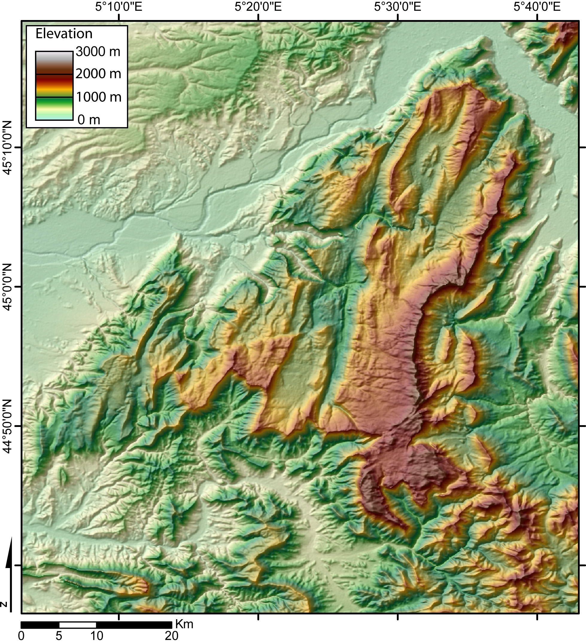
And below you can see the elevation model of the plateau

And now let me show you some pictures from this place!

A typical street in the old center of Die

One of the old access gate of Die

A small village on the way

The beginning of the trek, the aim of the day is to reach the top!!!

Closer and closer from the pass...

Die is in the third valley under the fog

Somewhere on the slope of the mountain

The lost valley....

On this panorama you can see the pass we reached in the top right corner

A kind of wild goat called chamoix

Finally the Bachasson pass (1661 m) where we planed to pitch the tente

It sounds like in the bush, isn't?

The sunset from the pass


The area of Die is also knows for his sparkling white wine called "clairette de Die". So it was a moral obligation for us to bring a bottle to the summit!!!! It's a sweet wine, not too strong in alcohol (only 7%), and the taste is really fruity.

Pssccchhhhhhh...

A nice & quiet place

I didn't sleep very well, maybe the nighte was too cold for me....
Like you can see the spring which was 50m far from the tente was a bit frozen in the morning!!!


You can see that the shortiest way to the valley is just a jump!!!
 A typical street in the old center of Die
 One of the old access gate of Die
 A small village on the way
 The beginning of the trek, the aim of the day is to reach the top!!!
 Closer and closer from the pass...
 Die is in the third valley under the fog
 Somewhere on the slope of the mountain
 The lost valley....
 On this panorama you can see the pass we reached in the top right corner
 A kind of wild goat called chamoix
 Finally the Bachasson pass (1661 m) where we planed to pitch the tente
 It sounds like in the bush, isn't?
 The sunset from the pass
 The area of Die is also knows for his sparkling white wine called "clairette de Die". So it was a moral obligation for us to bring a bottle to the summit!!!! It's a sweet wine, not too strong in alcohol (only 7%), and the taste is really fruity.
 Pssccchhhhhhh...
 A nice & quiet place
 I didn't sleep very well, maybe the nighte was too cold for me....

 You can see that the shortiest way to the valley is just a jump!!!